
Singapore MRT map
The full MRT and LRT network on one map — 6 MRT lines, 3 LRT systems and 146 MRT stations, updated after the Circle Line loop opened on 12 July 2026.
The MRT network map
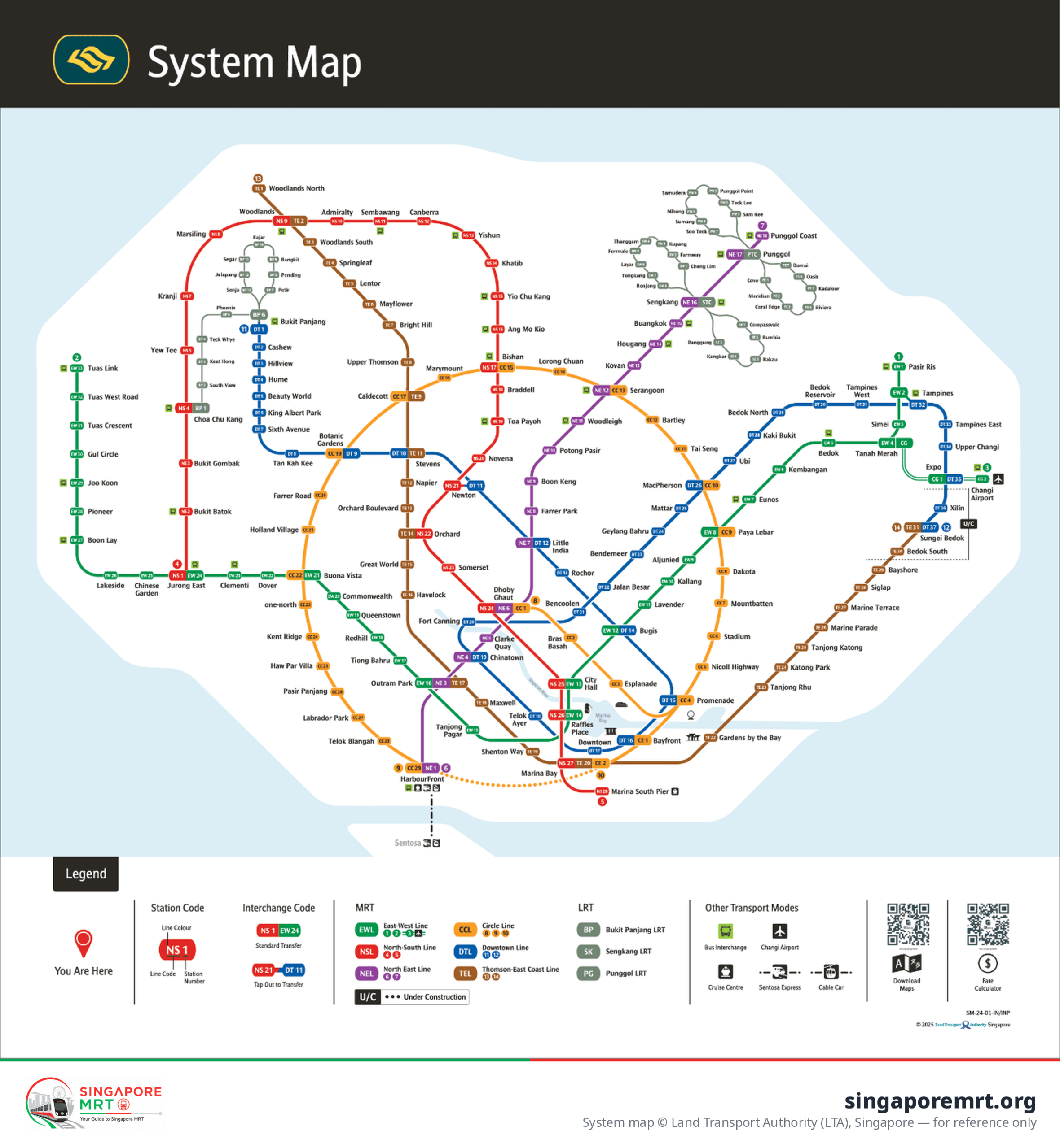
System map © Land Transport Authority (LTA), Singapore. Reproduced for reference — always check the official map at the station for the latest version.
Download the Singapore MRT map (PDF)
Take the map with you: the PDF prints cleanly on A4 and works offline on your phone, which is handy when you are underground and the signal drops.
Keppel (CC30), Cantonment (CC31) and Prince Edward Road (CC32) entered service on 12 July 2026, joining HarbourFront to Marina Bay and turning the Circle Line into a true loop after 17 years. Bayfront and Marina Bay have been renumbered CC34 and CC33 — the old CE1 and CE2 codes are gone, so any map still showing a "Marina Bay branch" is out of date.
Lines, colours and interchanges
The 29 interchange stations
About the MRT map
Six MRT lines — North South, East West, North East, Circle, Downtown and Thomson-East Coast — plus three LRT systems. Together they cover 246.6 km with 146 MRT stations and 38 more LRT stops.
Yes — use the download button above. The PDF is the current system map and prints on A4; you can also save the PNG image to your phone so it works without a signal underground.
There are 29 interchange stations. Three of them — Newton, Tampines and Bukit Panjang — are out-of-station interchanges, where you tap out and tap back in; it still counts as one journey if you take 15 minutes or less.
It should be. Since 12 July 2026 the Circle Line is a closed loop: Keppel, Cantonment and Prince Edward Road joined HarbourFront to Marina Bay. If your map still shows a “Marina Bay branch” with CE1 and CE2, it predates the opening.
Add this site to your favourites
We check Singapore MRT regularly and update it when the operators change timetables or fares or publish an important notice. Save the page and look at it before you travel.